Chobe River

The Chobe River forms Botswana’s northern border with Namibia’s Zambezi Region before joining the Zambezi near Kasane, and it is the only reliable water for a very long way in any direction, which is why the largest elephant concentrations in Africa gather along it. It also changes its name four times between its source in Angola and its mouth, and in some years it flows backwards. Boat safaris on the Chobe are among the best wildlife viewing in southern Africa.
The River With Four Names
The Chobe is not really its own river. It is the last stretch of a much longer system, and following the names is the easiest way to understand the geography of northern Botswana.
It rises in the central highlands of Angola, where the Utembo and Cuando merge, and is known there as the Cuando or Kwando. It flows southeast, forming the boundary between Angola and Zambia for around 225 kilometres.
Crossing Namibia’s Caprivi Strip, it meets a fault line that forces it into a sharp turn to the northeast and spreads into a marsh area of roughly 1,425 square kilometres, including Lake Liambezi. From this point it is the Linyanti.
Some accounts add a further name, Itenge, for the stretch near Parakurungu.
Near Ngoma Bridge it emerges from the wet alluvial plain as the Chobe, running east until it clears the Kasane Rapids and joins the Zambezi.
The name changes reflect regional usage, fault lines and geographical features rather than any change in the water itself.
The Cuando, Kwando, Linyanti and Chobe are the same river. Around ten thousand years ago it joined the Okavango and flowed south to Lake Makgadikgadi, until the land uplifted and it was captured by the Zambezi instead.
The River That Flows Backwards
The Chobe’s most unusual behaviour is the reason its floodplains are as productive as they are.
The river holds water year round, and rises considerably between roughly February and May following rains that fell in Angola from November onwards.
During that period the Zambezi floodplains rise too, and the Zambezi pushes water back up into the Chobe, filling the seasonal Lake Liambezi. Once the lake reaches saturation, water begins moving in the opposite direction from its normal course.
This backflow is why the Chobe floodplains hold water and support the vegetation that draws game in numbers no inland pan could sustain.
The Chobe’s own water level rises in May and reaches peak flood in June, slightly out of step with the Okavango further west.
Total length figures for the whole system run to around 735 kilometres, while the Chobe stretch proper is commonly given as roughly 150 kilometres.
Wildlife on the Chobe River
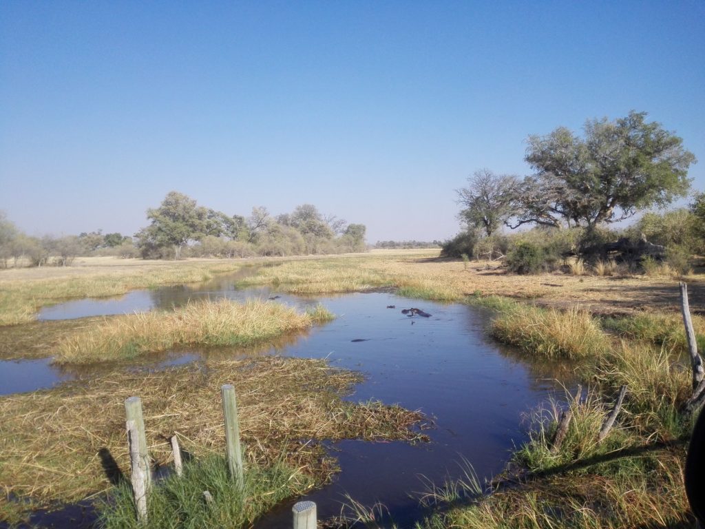
The riverfront supports the highest elephant density in Africa, and the mechanism is simple.
Through the dry season, from around May to October, surface water inland disappears entirely. The Chobe becomes the only reliable drinking water for a very long distance, so the herds come to it. Several hundred elephants along one stretch of bank in an afternoon is a normal day rather than a lucky one.
Elephant cross to the islands and swim, which is worth seeing once. Buffalo arrive in herds of hundreds, and lion follow the buffalo.
Hippo pods hold in the deeper water and crocodiles haul out on the sandbanks. Puku occur here in one of the few populations in the region, alongside red lechwe, waterbuck, sable and roan in the woodland behind.
Birdlife along the river is exceptional, with African skimmers working the shallows, fish eagles throughout, and carmine bee-eater colonies nesting in the banks around September.
Boat Safaris on the Chobe
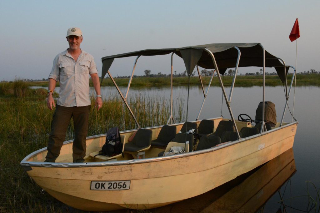
The water is what sets Chobe apart from every other safari area in Botswana, and it is a genuinely different way of seeing wildlife.
From a boat you sit at eye level with drinking elephant rather than looking down from a vehicle. Hippos surface a few metres away. Crocodiles lie on sandbanks close enough to see properly.
Boat safaris also reach places no vehicle can, working the channels and island edges where much of the activity happens.
Afternoon cruises are the standard, timed to end with a sundowner as the light goes, and they suit the heat better than a drive. Morning boat trips are quieter and often better for birds.
Vessels range from large multi-deck cruisers taking many passengers to small photographic boats with a handful of people, and the difference matters. Photographers should ask for the small boats by name.
Both Botswana and Namibian operators run trips on the river, since it is an international boundary.
Dry season, May to October. Peak elephant and buffalo concentrations as inland water disappears. Boat safaris at their best, with game packed onto the riverbank. Busiest months on the water.
Green season, November to April. Game disperses inland as pans fill, but the river holds up better than anywhere inland because the water is permanent. Birding at its strongest, rates considerably lower.
February to May. The river rises following Angolan rains, the Zambezi pushes water back up the channel and Lake Liambezi fills. The backflow that makes the floodplains productive.
Where the Four Countries Meet
The confluence of the Chobe and the Zambezi is one of the more geographically curious spots in Africa.
Near Kazungula, Botswana, Namibia, Zambia and Zimbabwe come within a very short distance of one another. The site is often described as a quadripoint, the only place on earth where four countries meet.
The reality is slightly less tidy and more interesting. It is now widely accepted that there are two tripoints, one where Botswana, Zambia and Namibia meet and another where Botswana, Zambia and Zimbabwe meet, lying around 150 metres apart. Our Chobe itinerary sets out how many nights the riverfront really needs.
The confluence itself sits roughly ten kilometres below the Mambova Rapids, which the Zambezi clears, and just past the Kasane Rapids, which the Chobe clears.
Kasane sits at this junction, which is why it functions as a gateway to four countries and why Victoria Falls is only around 80 kilometres away.
The whole region falls within the Kavango-Zambezi Transfrontier Conservation Area, the largest conservation area in the world.
Visiting the Chobe River

Access is the easiest of any major safari area in Botswana.
Kasane International Airport connects to Johannesburg, Gaborone and Maun, and the Sedudu Gate into Chobe National Park is minutes away by road. No internal charter flight is required, which makes this the cheapest safari area in the country to reach.
Riverfront lodges cluster around Kasane and extend west toward Ngoma, with the western end considerably quieter.
Park entry runs at 120 Pula per person per day for non-residents, or 70 Pula through a licensed Botswana operator.
Boat trips can be booked through lodges or independently in Kasane, and day visitors from Victoria Falls swell the numbers on the water in the middle of the day.
Ihaha campsite serves self-drive visitors on the riverfront inside the park.
One practical note about the border. Because the river is an international boundary, boats operating from the Botswana bank stay on the Botswana side of the channel and Namibian operators stay on theirs, which occasionally puts a good sighting on the wrong side of an invisible line. Guides handle this without fuss, and it is worth knowing so that a boat holding position rather than crossing does not read as reluctance.
Take an early morning boat rather than the standard afternoon cruise if you can. The afternoon is when day trippers from Victoria Falls are on the water, while mornings are quieter, better for birds and give you the riverbank largely to yourself.
Frequently Asked Questions About the Chobe River
Where does the Chobe River start and end?
It rises in the central highlands of Angola as the Cuando, formed where the Utembo and Cuando merge, then flows southeast forming the Angola and Zambia boundary for around 225 kilometres. Crossing Namibia’s Caprivi Strip it turns sharply northeast into the Linyanti marshes, becomes the Linyanti, and emerges near Ngoma Bridge as the Chobe. It joins the Zambezi near Kasane after clearing the Kasane Rapids. The whole system runs to around 735 kilometres.
Why does the Chobe River flow backwards?
Because of the Zambezi. The Chobe rises between roughly February and May following rains that fell in Angola from November. During the same period the Zambezi floodplains rise and push water back up into the Chobe, filling seasonal Lake Liambezi. Once the lake saturates, water starts moving opposite to its normal course. This backflow is what keeps the Chobe floodplains productive and supports the vegetation that draws such large herds.
Why are there so many elephants on the Chobe River?
Because through the dry season it is the only reliable water for a very long distance. Surface water inland disappears from around May, so the herds have no alternative and come to the river, producing the highest elephant density in Africa. Several hundred animals along one stretch of bank in an afternoon is normal here. Buffalo follow the same pattern in herds of hundreds, with lion following them.
What is the best time for a Chobe River boat safari?
The dry months from May to October give the highest concentrations, with peak game viewing between August and October as inland water vanishes entirely. Within a day, early morning is quieter and better for birds, while afternoons carry the day visitors coming across from Victoria Falls. The green season from November to April disperses the game inland, though the riverfront holds up better than anywhere inland because the water is permanent.
Do four countries really meet on the Chobe River?
Nearly. Near Kazungula, where the Chobe joins the Zambezi, Botswana, Namibia, Zambia and Zimbabwe come within a very short distance of each other, and the spot is widely described as the only quadripoint on earth. It is now widely accepted that there are actually two tripoints around 150 metres apart, one joining Botswana, Zambia and Namibia and another joining Botswana, Zambia and Zimbabwe.
Can you do a Chobe boat safari without staying in Botswana?
Yes. The river is an international boundary, so both Botswana and Namibian operators run trips on it, and day trips from Victoria Falls in Zimbabwe are extremely common, with Kasane around 80 kilometres away by road including the Kazungula border crossing. Day trips typically pair a morning game drive with an afternoon river cruise. Staying overnight gives you considerably more, particularly the early mornings.
Booking Your Botswana Trip
The safari companies and tour operators listed on this website put trips like this together for a living and know which camps, guides and routes actually deliver. We are an independent guide to Botswana; we do not book or sell tours ourselves.
When you are ready, arrange your safari, tour or holiday with one of the recognised operators listed here. Tell them your dates and what matters most, and a real person, not a form, will handle the itinerary, park bookings and logistics for you.